Waveform inversion for 3-D Earth structure 3000 km beneath the Western Pacific The root of the Caroline hotspot
From its surface to its center, the Earth is composed of the crust, mantle, outer core and inner core. The lowermost few hundred kilometers of the mantle just above the outer core is called the D” (pronounced dee double prime) region. The chemistry and temperature of the D” region change rapidly near the boundary with the liquid iron-alloy outer core. The flux of energy and material through this layer is vital to understanding the Earth’s evolution from the perspective of the thermochemical evolution of the mantle, but its detailed structure remains unknown.
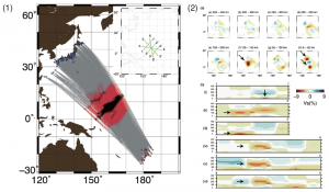
Adapated from Figure 1 and Figure 4, Waveform inversion for localized three-dimensional seismic velocity structure in the lowermost mantle beneath the Western Pacific, Konishi et al., Geophysical Journal International, 199: 1245-1267, 2014.
(1) Event-receiver geometry with great circle ray paths. Earthquakes are red circles beneath Tonga and Fiji, and seismic stations are blue triangles in Japan. Raypaths in the red area sample the D’’ region. The inset at the top right of this panel shows the locations of the six cross-sections in panel 2b. (2)(a) Map views of the lateral heterogeneity of S velocities obtained by the inversion relative to the average velocity for that depth. (2)(b) Six cross-sections at the locations shown in the inset in panel 1. An ‘inverse-Y tower-shaped’ low-velocity anomaly with a height of 300 km (panels v and vi of the cross sections in the lower half of panel 2, see arrows) can be seen.
In this study, University of Tokyo Professor Robert Geller (Graduate School of Science) and Assistant Professor Kawai Kenji (Graduate School of Arts and Sciences) and their colleagues analyzed a large volume of seismograms for earthquakes under the Tonga-Fiji region recorded by a dense array of seismographs in Japan. The raypaths sample the D” region of the lowermost mantle beneath the western Pacific. The study used new highly accurate methods for inversion of seismic waveform data which were developed by Profs. Geller and Kawai and their colleagues to obtain a 3-dimensional (3D) model of the seismic velocity structure in this region. An “inverse-Y tower shaped” low velocity region was found, which is interpreted as hot material rising convectively from the base of the mantle which is the source of the Caroline Hotspot. This had previously been suggested on the basis of noble gas isotope data, but seismological studies had heretofore lacked the resolution to image this feature.
Press release (Japanese)
Paper
Konishi, K., K. Kawai, R.J. Geller and N. Fuji,
“Waveform inversion for localized 3-D seismic velocity structure in the lowermost mantle beneath the Western Pacific”,
Geophysical Journal International, (November, 2014) 199 (2): 1245-1267. doi: 10.1093/gji/ggu288.
Article link
Links
Department of Earth and Planetary Science, Graduate School of Science


