


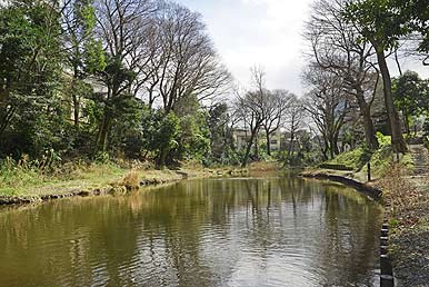
Approximately 130,000 years ago, the entire Kanto Plain was underwater. Sediment carried by rivers gradually accumulated at the floor of this inland sea, creating a flat surface called the “Tokyo layer.” Over the course of the next several centuries, the sea level fell, and the Kanto Plain rose from the ocean as a large tableland of flat terrain. The tableland was raised up higher, and a terrace was formed due to the “Kanto loam,” a layer of volcanic ash composing part of its sediment. This volcanic ash layer eventually hardened into clay and became able to hold water, resulting in ponds forming on top of it. The Komaba area features two valleys: one caused by the Shibuya River system in the northeast and one formed by the Meguro River system in the south. The pond on Komaba Campus (also called Ichiniro Pond) is the origin of one of Meguro River’s tributaries. Records state that this pond was also used as a fishery by the College of Agriculture during the Meiji period.


