


Data from Türkiye-Syria earthquake helps mitigate future disasters What we can do to prepare for “once-in-a-century” events
The devastating earthquake that struck near the border of Türkiye (Turkey) and Syria in February 2023 has resulted in over 50,000 fatalities. Associate Professor Hiroe Miyake of the Earthquake Research Institute, who researches earthquake ground motion, discusses the characteristics of the massive inland earthquake.
Not entirely unexpected
── What are some of the features of the recent earthquake?
The main feature that defines this earthquake is that it was a large-scale inland earthquake. It is only in the last 50 years or so that we have been able to accurately calculate and observe the magnitude of earthquakes around the world, and in that period, only a few earthquakes of such a large magnitude have occurred along inland faults. A similar inland earthquake occurred in Sichuan Province in China in 2008, in which about 90,000 people were recorded as dead or missing. Tectonically speaking, in Japanese terms the Türkiye (Turkey)-Syria earthquake was equivalent to a slip along the entire Median Tectonic Line, which spans the main island of Kyushu in the southwest through the south-central Kansai region on Japan’s largest island, Honshu. Needless to say, when an earthquake of this magnitude strikes areas on land where people live, it causes a lot of damage.
Another feature of this earthquake is its intensity. The observation equipment recorded continuous, strong shaking across a wide-ranging area.
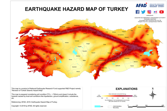
©Disaster and Emergency Management Authority (AFAD)
https://deprem.afad.gov.tr/content/56
── Was there an awareness that an earthquake of this scale could occur in the affected area?
The location where the earthquake hit was not unexpected. When you look at the latest version of Türkiye’s earthquake hazard map, you can see that the North Anatolian Fault runs from east to west and the East Anatolian Fault extends from the southwest to the northeast. We also know from fault trench surveys that earthquakes have occurred repeatedly in the area for a long time. Furthermore, historical records documenting earthquakes were commonly kept and are preserved in Türkiye, which is home to numerous religious institutions and World Heritage sites. At the time of the Great East Japan Earthquake in 2011, the 869 Jōgan earthquake gained media attention as a historical earthquake (i.e., an earthquake that is verified through written records and evidence from archaeological sites) because it shared many of the same features as the earthquake and tsunami that affected the same region more than 1,100 years later. Some of the descriptions of Türkiye’s historical earthquakes, though, date back even further to at least as early as 521.
The scale of the recent earthquake, however, far exceeded our previous expectations. Nine hours after the first earthquake, another large-scale earthquake hit. Aftershocks have been occurring for weeks, and there are indications that further earthquakes may occur in Türkiye and further south. The Dead Sea Fault Zone that borders the Dead Sea has been the site of repeated earthquakes in the past, and some researchers fear this latest earthquake may have triggered a future quake in the area.
Observation and preparation
── Had observation equipment been placed in earthquake-prone areas?
Although the government was criticized for not providing the public with the information they needed immediately after the earthquake, the seismic data Türkiye has collected that is used by experts is top-notch. An organization under direct control of the presidential administration has dedicated a considerable portion of its budget to preparing for natural disasters, including installing a massive quantity of observation equipment, which has ensured that data was recorded from the recent earthquake.
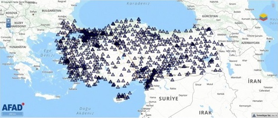
©Disaster and Emergency Management Authority (AFAD)
The data collected from the earthquake was publicly available online the following day. In the case of Japan, there were few observation stations at the time of the Great Hanshin-Awaji Earthquake in 1995 (which rocked the city of Kobe and the surrounding area in south-central Japan) and the establishment of new stations followed as a consequence. In addition, the Great East Japan Earthquake, which occurred offshore, showed that it was not sufficient to set up observation stations only on land, and this led to the establishment of observation stations in the ocean through the use of cables along the seafloor. Although it requires huge outlays, observation is essential to Earth science, and I feel Japan has a lot to learn from Türkiye.
── Why was the damage so extensive despite such well-recorded data?
The people who live in the area affected by this earthquake must have known about the existence of the East Anatolian Fault. An enormous number of fatalities resulted from the 1939 Erzincan earthquake in Türkiye, which is commemorated each year on Dec. 27, and knowledge about the earthquake has been passed down through the generations. We also hear that in recent years, Istanbul and other cities more than 1,000 kilometers away from the epicenter of this most recent earthquake have been carrying out disaster drills and education initiatives in preparation for earthquakes. However, unlike tsunamis, strong earthquakes on land cause buildings to collapse as soon as ground shaking begins, making it difficult to gain time to escape.
One important measure that could be considered in a region like Türkiye would be to improve the earthquake resistance of hospitals and schools. In fact, I have heard that some of the public buildings in Türkiye were quite sturdy. But, the life span of human beings and the planetary timescale on which the Earth revolves are vastly different. This makes it difficult to determine how individuals and society can prepare for major earthquakes like this one that may only occur once in several centuries.
Further investigation
── What other points would you like to investigate and clarify going forward?
There are two points that I am concerned about: One is why such strong ground motion was observed. Given the scale of the earthquake, we initially thought that the predominant waves were slightly slower with long periods, which would have caused damage to high-rise buildings. However, contrary to our expectations, the actual data showed predominant waves with shorter periods of 1-3 seconds, resulting in the collapse of many buildings that weren’t very tall.
The other point is the differing nature of the affected areas to the north and to the south. Satellite imagery shows that in the north, the ground shifted nearly 10 meters, while we have notably not received any such reports about the south. On the other hand, damage to buildings was very severe in the south, where the data shows there was powerful shaking. We would like to investigate why we see such a discrepancy between the north and the south regarding the size of fault displacement caused by the earthquake that we can observe geoscientifically, and the degree of damage actually caused by the shaking.

Hiroe Miyake
Associate Professor, Earthquake Research Institute, The University of Tokyo
Ph.D. (Geophysics) from the Division of Earth and Planetary Sciences of the Graduate School of Science at Kyoto University. Assumed current position in 2020 after working at the Center for Integrated Disaster Information Research in UTokyo’s Interfaculty Initiative in Information Studies, following an earlier appointment in the Earthquake Research Institute.
Interview date: March 9, 2023
Interview: Yuki Terada, Hannah Dahlberg-Dodd


