Delayed Arctic ice advance tracked back to atmospheric conditions near Alaska months prior Unusual conditions in 2018 analyzed to improve Arctic sea ice forecast Research news

December 16, 2020

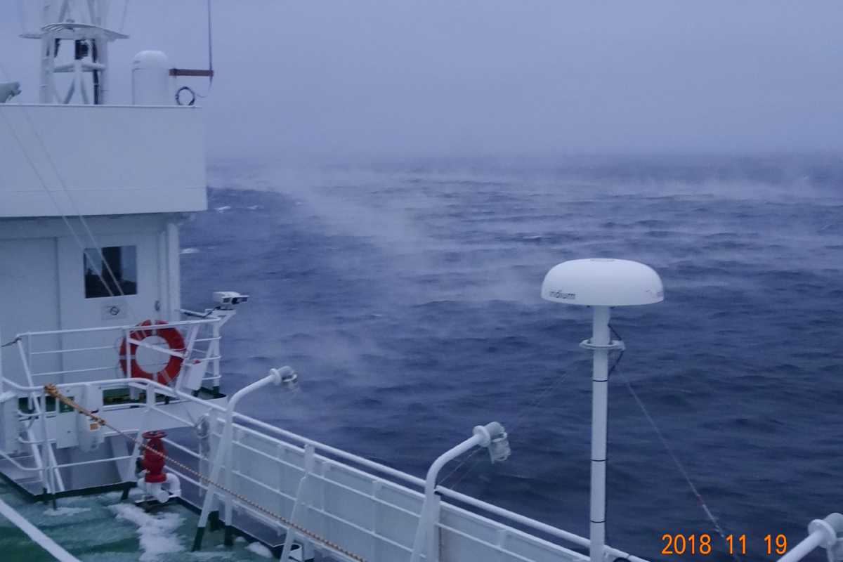
Researchers aboard the research vessel Mirai watched water vapor rise from the Chukchi Sea, resembling the mist that rises from a hot bath in a cold room. The Pacific Ocean brings relatively warm 2-degree Celsius water into the Arctic Ocean, where much colder minus 10-degree Celsius winds blow across the surface. © Jun Inoue, National Institute of Polar Research, CC BY-SA.
Experts in Japan recently discovered that atmospheric conditions near Alaska can affect sea ice conditions in the Arctic Ocean months later. The team used various data, including ship-based data from 2018, to uncover how a single atmospheric event over the northern Pacific Ocean caused significantly delayed sea ice formation in the Pacific Arctic region.
“Global warming is going on, so the global mean surface air temperature is increasing, but compared to that trend, the Arctic is warming twice or more as fast,” said Assistant Professor Tsubasa Kodaira, first author of the recent research publication and an expert in applied physical oceanography from the University of Tokyo.
One important heat source in the Arctic is warm Pacific seawater. The seawater flows northward into the Bering Sea, then through the narrow, 85-kilometer wide opening of the Bering Strait into the Chukchi Sea and onward into the Arctic. Researchers aboard the research vessel Mirai in November 2018 recorded water conditions for 12 consecutive days while sailing along the edge of sea ice in the Chukchi Sea. Despite ideal atmospheric conditions for sea ice formation, researchers recorded that the water surface remained unusually warm and ice-free.
The delay of sea ice formation in 2018 was remarkable even in an era of climate change turning extreme weather into regular events. Sea ice coverage of the Chukchi Sea remained 20% less from Nov. 13 through Dec. 4, 2018, compared to the average from 2002 to 2017.
The research team analyzed satellite recordings of sea surface temperature of the Chukchi Sea from 2002 to 2018. During the months when sea ice formed, the fluctuations of seawater temperature closely matched fluctuations of the Pacific Decadal Oscillation (PDO) index, large-scale and long-term sea surface temperature variations over northern regions of the Pacific. Despite this two-decade association between Chukchi Sea temperature and the PDO index, when the Chukchi Sea was at its warmest in November 2018, the PDO was neutral.
The research team looked specifically at monthly sea surface temperatures from August through November in every year. Typically, seawater temperature cooled by about two degrees each month as summer fades to winter. In 2018, the temperature remained the same as August in September.
“So, something was happening in summer to create the unusual warm seawater observed by Mirai in November 2018,” said Kodaira.
Researchers then examined additional atmospheric satellite data recordings and noticed sustained, unusually high air pressure over the Bering Sea in September 2018. This high pressure is known as atmospheric blocking and leads to stationary weather patterns. This atmospheric blocking caused a sustained increase in wind blowing northward over the Bering Strait.
Kodaira’s team estimates that these winds led to 70% more water than average flowing from the Pacific into the Arctic.
“This large volume of additional warm Pacific water was likely what prohibited sea ice advance towards the south in November 2018,” said Kodaira.
Researchers regard the September 2018 Bering Sea atmospheric blocking event as unusual because although such events are common in the region during the winter, they are significantly less common in the summer and autumn.
The unusual atmospheric blocking in September and remarkably delayed sea ice formation in November occurred during a year with a neutral PDO index. The study of Kodaira’s team also showed that seawater temperatures increase by a full 1 degree Celsius during a positive phase of PDO index.
If atmospheric blocking were to occur simultaneously with a positive PDO index, researchers predict sea surface temperatures in the Arctic could rise by approximately 2 degrees Celsius, dramatically reducing — not just delaying — annual sea ice growth.
The Pacific Arctic region, including the Chukchi Sea, was previously known to have experienced a significant reduction of summer sea ice and this new study has demonstrated one mechanism of how sea ice formation can be delayed. The researchers hope that their new findings will lead to better predictions of Arctic sea ice formation, benefiting global weather forecasting and predictions of local Arctic ecosystem health.
Papers
Tsubasa Kodaira, Takuji Waseda, Takehiko Nose and Jun Inoue, "Record high Pacific Arctic seawater temperatures and delayed sea ice advance in response to episodic atmospheric blocking," Scientific Reports: November 27, 2020, doi:10.1038/s41598-020-77488-y.
Link (Publication )
)


