Find a book


Title
Cartographic Japan A HISTORY IN MAPS
Size
336 pages, 8 1/2 x 11 inch
Language
English
Released
March, 2016
ISBN
9780226073057
Published by
The University of Chicago Press
Book Info
See Book Availability at Library
Japanese Page
When looking at history, its meaning will differ depending on whether one looks at it from within or observes it from the outside. In the former case, importance can be placed on elucidating the meaning of ways of thinking and views that one currently takes for granted and relativizing and objectifying them, whereas in the latter case it is usual to deal with history purely as an object of analysis and as a heterogeneous other quite separate from oneself. In this case, there will sometimes lurk certain expectations of exoticism. How to mutually understand this gap and engage in mutual dialogue is becoming an issue in a globalizing world.
This book takes up maps depicting “Japan” and the surrounding world from the sixteenth century to the 2011 Great East Japan Earthquake, and Japanologists from Japan, North America, and Europe each present their analyses of “a history in maps” (the book’s subtitle). The education and common knowledge of the contributors are not necessarily all the same. Their perspectives cover a wide range of specialities—not just history, but also geography, painting, cultural properties, architecture, art history, literature, religious studies, information science, history of science, cultural anthropology, and East Asian area studies—and this book has the character of a collection of essays coauthored by researchers living in “Japan” and researchers viewing “Japan” from the outside. The current state of research about Japanese history is one in which findings published in Japanese form their own current of research that is separate from findings published in English. Behind this lie the numerous moves by local government bodies since modern times to make public and publish the vast corpus of local historical sources, and behind these moves there lay the investigations by local residents of their own history and the achievements of their ancestors since the early modern period. In such circumstances, the research history that the contributors take for granted is not uniform.
The distinctive feature of this book is that, such being the state of the field, instead of each contributor freely revealing their own view of “Japan,” they take up maps drawn by people in different periods and discuss individual historical phenomena with reference to high-definition illustrations. What is important is the fact that maps possess the basic character of having been produced in order to appeal to people outside the local community and have them understand the local situation. Maps are not necessarily needed by people who share a narrowly circumscribed culture, sense of values, and thinking and also an everyday spatial awareness. They can communicate adequately by the spoken and written word. Maps could be said to be tools for addressing and appealing to others who do not share the same common knowledge. How did those who produced the maps attempt to describe their own worldview and way of looking at things to people who were for them the “other”? And where does the analyst’s own position lie vis-à-vis this relationship? Through the task of analyzing these maps, the contributors were compelled to examine their own position as well.
The aim of this book was not to present a fixed conclusion about “Japan” as seen from cartography, but to provide a platform for open discussion. And the still more important significance of this book lies in the fact that, by utilizing this power of maps, it has made it possible to describe not only to researchers but also to ordinary people in the non-Japanese-speaking world the views of “Japan” held by people in different periods and the current state of the very latest research about “Japan.”
(Written by Fumiko Sugimoto, Professor, Historiographical Institute / 2018)
Table of Contents
Kären Wigen
I. Visualizing the Realm: Sixteenth to Eighteenth Centuries
Introduction to Part I
Sugimoto Fumiko
Japan in the World
1. Japan in a New-Found World
Joseph Loh
2. The World from the Waterline
Peter D. Shapinsky
3. Elusive Islands of Silver: Japan in the Early European Geographic Imagination
Oka Mihoko
4. Mapping the Margins of Japan
Ronald P. Toby
5. The Creators and Historical Context of the Oldest Maps of the Ryukyu Kingdom
Watanabe Miki
6. The Introduction of Dutch Surveying Instruments in Japan
Satoh Ken’ichi
7. The European Career of Ishikawa Ryusen’s Map of Japan
Marcia Yonemoto
8. A New Map of Japan and Its Acceptance in Europe
Matsui Yoko
Domestic Space
9. The Arms and Legs of the Realm
Constantine N. Vaporis
10. Visualizing the Political World through Provincial Maps
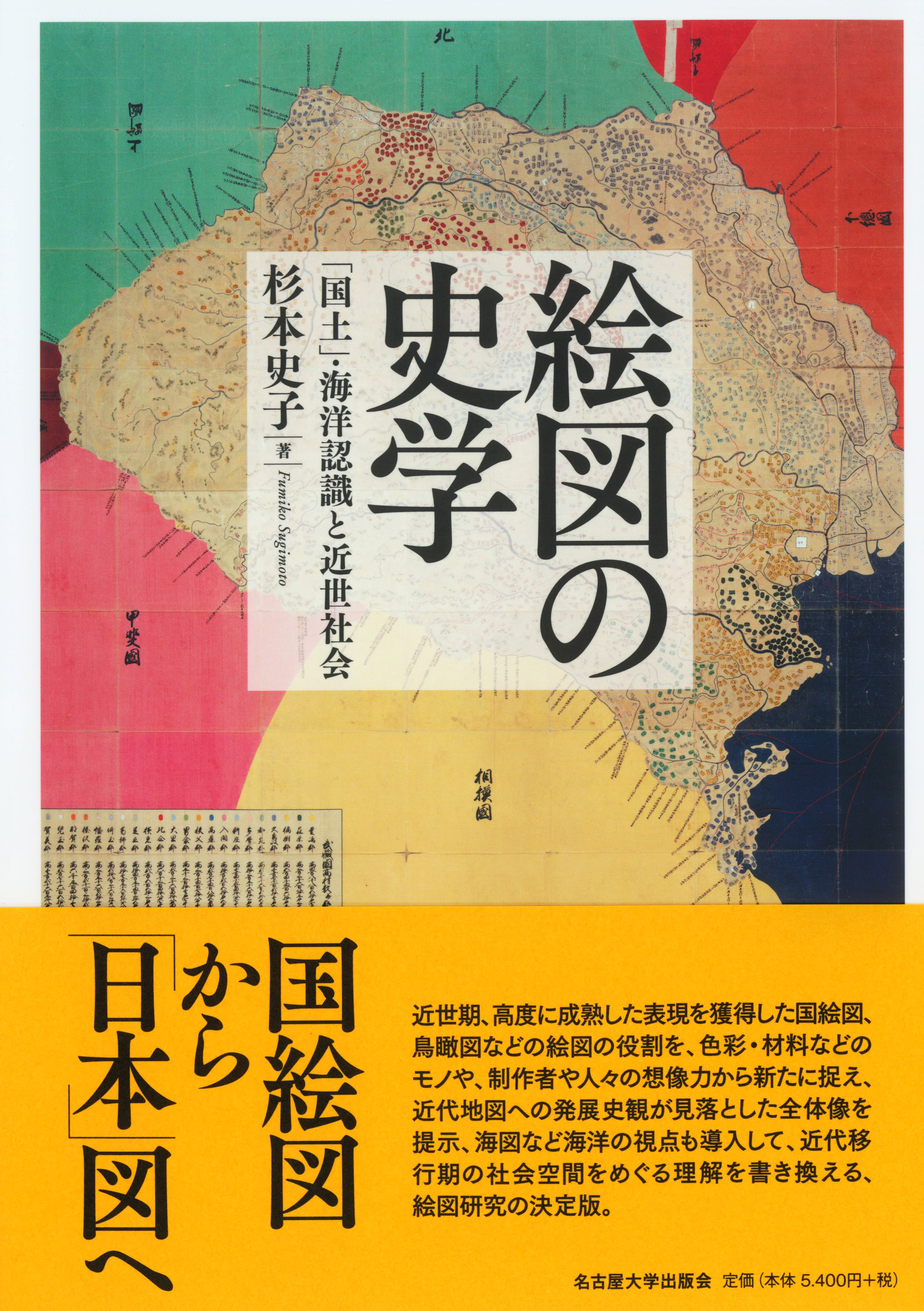
Sugimoto Fumiko
11. Fixing Sacred Borders: Villagers, Monks, and Their Two Sovereign Masters
Sugimoto Fumiko
12. Self-Portrait of a Village
Komeie Taisaku
II. Mapping for the Market
Introduction to Part II
Kären Wigen
Mapping the City
13. Characteristics of Premodern Urban Space
Tamai Tetsuo
14. Evolving Cartography of an Ancient Capital
Uesugi Kazuhiro
15. Historical Landscapes of Osaka
Uesugi Kazuhiro
16. The Urban Landscape of Early Edo in an East Asian Context
Tamai Tetsuo
17. Spatial Visions of Status
Ronald P. Toby
18. The Social Landscape of Edo
Paul Waley
19. What Is a Street?
Mary Elizabeth Berry
Sacred Sites and Cosmic Visions
20. Locating Japan in a Buddhist World
D. Max Moerman
21. Picturing Maps: The “Rare and Wondrous” Bird’s-Eye Views of Kuwagata Keisai
Henry D. Smith II
22. An Artist’s Rendering of the Divine Mount Fuji
Miyazaki Fumiko
23. Rock of Ages: Traces of the Gods in Akita
Anne Walthall
24. Cosmology and Science in Japan’s Last Buddhist World Map
Sayoko Sakakibara
Travelscapes
25. Fun with Moral Mapping in the Mid-Nineteenth Century
Robert Goree
26. A Travel Map Adjusted to Urgent Circumstances
Kären Wigen and Sayoko Sakakibara
27. Legendary Landscape at the Kitayama Palace
Nicolas Fiévé
28. New Routes through Old Japan
Roderick Wilson
III. Modern Maps for Imperial Japan
Introduction to Part III
Cary Karacas
Defining the Borders
29. Seeking Accuracy: The First Modern Survey of Japan’s Coast
Suzuki Junko
30. No Foreigners Allowed: The Shogunate’s Hydrographic Chart of the “Holy” Ise Bay
Suzuki Junko
31. Indigenous Knowledge in the Mapping of the Northern Frontier Regions
Tessa Morris-Suzuki
32. Mamiya Rinzo and the Cartography of Empire
Brett L. Walker
33. Outcastes and Peasants on the Edge of Modernity
Daniel Botsman
Transforming the Cityscape
34. Converging Lines: Yamakawa Kenjiro’s Fire Map of Tokyo
Steven Wills
35. Mapping Death and Destruction in 1923
J. Charles Schencking
36. Rebuilding Tokyo after the Great Kanto Earthquake
André Sorensen
37. Shinjuku 1931: A New Type of Urban Space
Henry D. Smith II
Managing an Empire
38. Mapping the Hojo Colliery Explosion of 1914
Brett L. Walker
39. Cultivating Progress in Colonial Taiwan
Philip C. Brown
40. Showcase Thoroughfares, Wretched Alleys: The Uneven Development of Colonial Seoul (Keijo)
Todd A. Henry
41. Imperial Expansion and City Planning: Visions for Datong in the 1930s
Carola Hein
42. A Two-Timing Map
Catherine L. Phipps
43. Visions of a New Order in the Asia-Pacific
David Fedman
IV. Still under Construction: Cartography and Technology since 1945
Introduction to Part IV
Kären Wigen
Up from the Ashes
44. Blackened Cities, Blackened Maps
Cary Karacas and David Fedman
45. The Occupied City
Cary Karacas
46. Sacred Space on Postwar Fuji
Andrew Bernstein
47. Tange Kenzo's Proposal for Rebuilding Hiroshima
Carola Hein
48. Visions of the Good City in the Rapid Growth Period
André Sorensen
Growing Pains in a Global Metropolis
49. On the Road in Olympic-Era Tokyo
Bruce Suttmeier
50. Traversing Tokyo by Subway
Alisa Freedman
51. The Uses of a Free Paper Map in the Internet Age
Susan Paige Taylor
52. Tsukiji at the End of an Era
Theodore C. Bestor
New Directions in the Digital Age
53. Probabilistic Earthquake Hazard Maps
Gregory Smits
54. Citizens’ Radiation Maps after the Tsunami
Jilly Traganou
55. Run and Escape!
Satoh Ken’ichi
56. Postmortem Cartography: “Stillbirths” and the Meiji State
Fabian Drixler
57. Reconstructing Provincial Maps
Nakamura Yusuke
58. The Art of Making Oversize Graphic Maps
Arai Kei
Epilogue
Sugimoto Fumiko
Related Info
Choice Magazine: CHOICE Outstanding Academic Title Awards