UTokyo researchers answer questions on 21 GX (Green Transformation) topics from their specialist viewpoints. Through questions that cannot simply be brushed off as someone else’s concerns, take a peek into GX and our world of research.
Q20. What will happen to Japan’s rainy season if global warming continues?
The tsuyu/baiu (rainy season) reminds the Japanese of their bond with nature and its seasons. Rainy season is known for being long and damp, but has it been changing in recent years?Answered by Chie Yokoyama
Project Assistant Professor, Atmosphere and Ocean Research Institute
Meteorology

Three rainfall patterns in the rainy season
The rainy season is a phenomenon observed not only in Japan, but also much of East Asia from May to July each year. As the solar elevation rises and the Earth’s surface warms up, the atmospheric pressure over the land drops below that over the sea, generating seasonal winds which blow from the sea to the continent and carry in warm, moist air from the south. Warm, moist air wrapped in the Tibetan high-pressure system is also carried in from the southern part of the continent. High above, the jet stream blowing from west to east divides the atmosphere in a south-north direction into tropical and temperate zones, forming the baiu weather front. A front is the place where air masses of different temperature and humidity level collide and compete with each other. When moist air enters, the condition becomes unstable, leading to vertical mixing. A prolonged period of rainy weather follows. As summer approaches, the Pacific high-pressure system strengthens, the jet stream moves north, and the baiu front disappears again.
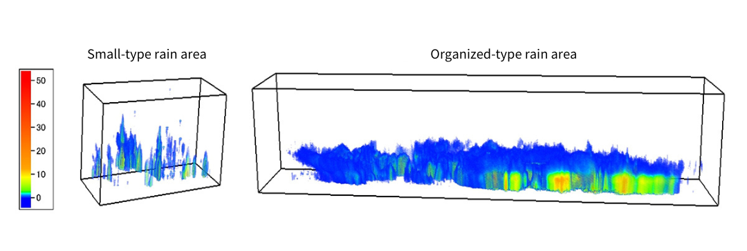
The rain in the rainy season can fall in several patterns. Using data from the Global Precipitation Measurement (GPM) and Tropical Rainfall Measuring Mission (TRMM) satellites, I have analyzed the three-dimensional structure of the rain that falls in this period. These satellites observe the vertical distribution of the rain by sending out a radio signal and measuring the time taken for the echo to return. From this data, we can understand that torrential rain can fall in either a narrow range from higher up in the sky, or in a wider range from a lower altitude, even though it all looks the same from a certain place near the Earth’s surface.
Looking at 13 years of satellite data, we can classify rainfall events in the rainy season into three types: small, organized and midlatitude. Short-lived and accompanied by thunder, small-type rain is common in regions where the sea surface temperature is high. In contrast, organized-type rain falls over a widespread area for long periods and is rarely accompanied by thunder. The latter is a common type of torrential rain. The small and organized types are common in the tropics, whereas the midlatitude type is a relatively light rainfall that accompanies extratropical cyclones. Low-altitude warm and damp air, the jet stream above it and the type of rainfall event all have an effect on rainfall during the rainy season.
The organized type of rainfall is spreading northwards
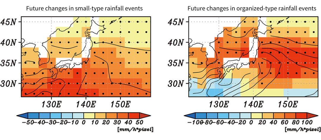
Next, we used projection data and historical experimental data from 25 selected climate models to predict future changes in the three types of rainfall events across Japan. We wanted to understand what type of relationship exists between the state of the atmosphere and how it rains, and how that relationship will change in the future. This method of linking satellite data with climate model projections is rather unconventional.
Based on the worst-case scenario for future global warming, we found that many regions would see an increase in organized-type rainfall events during the rainy season over the next 100 years. Organized rainfall is already frequently seen in western Japan, but it appears that this type of rainfall will spread to the Tohoku and Kanto regions in the coming 100 years. Caution is needed as the risk of disasters caused by torrential rain increases as organized rainfall events become more frequent. An increase in small-type rainfall events is also projected for all areas, with a particularly big rise along the Pacific Ocean coastline from Kyushu to Kanto, with sudden, violent thunderstorms possibly becoming more frequent as a result. Matching trends were produced by more than 90% of the climate models used.
Although the rainy season is peculiar to Asia, phenomena similar to the baiu weather front can also be found in South America and elsewhere. From now on, I would like to see if we can find similar results in those areas and investigate any differences.
* Project Assistant Professor Yokoyama’s affiliation and title are as of March 2023.


