


Information design and the Türkiye-Syria earthquake Post-disaster outreach through satellite imagery
The major earthquake that struck Türkiye and Syria caused enormous damage. Prof. Hidenori Watanave of the Interfaculty Initiative in Information Studies released a satellite images map immediately after the disaster and has continued to disseminate information on the damage. Here, he explains what can be done to get a full picture of the destruction.
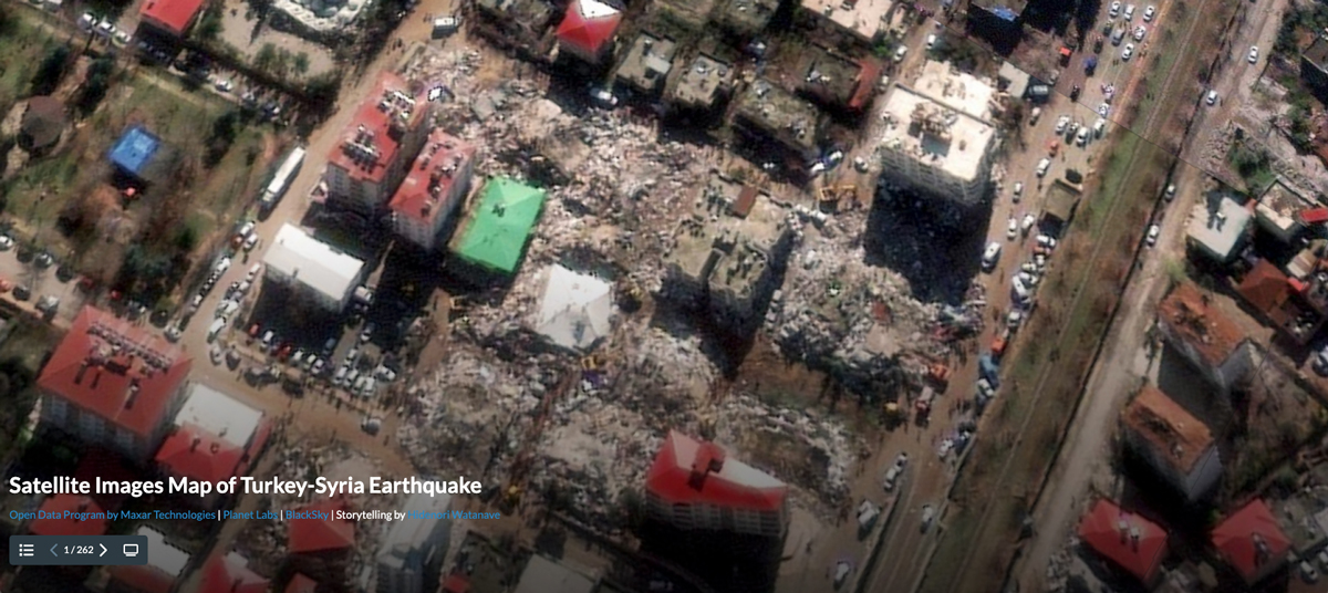
Satellite Images Map of Türkiye-Syria Earthquake
On making time-sensitive information immediately
── You started sending out information two days (February 8, 2023) after the earthquake in Türkiye and Syria.
トルコの地震による破壊状況を捉えた,Maxar Technologiesの衛星画像。現地の天候が悪く,光学衛星の画像は得られにくいようです。僕もSARイメージを用いた検証を始めます。 https://t.co/T69DWVPBnE
— 渡邉英徳 wtnv (@hwtnv) February 7, 2023
This earthquake is the first major disaster to occur since some commercial satellite imagery providers (see below) began releasing satellite images free of charge in the wake of the war in Ukraine in order to contribute to society and perhaps also to promote their corporate values. I analyzed the damage based on raw satellite image data and sent out a video overview of the situation on Twitter, which was accessed by approximately 28,000 users from Türkiye in the week after its release. At the time, it was difficult to make visual observations due to inclement weather over the area, so images were compiled using Synthetic Aperture Radar (SAR) data, wherein microwaves are emitted from a satellite to the ground and the reflected signals are used to observe the surface of the Earth.
── What kind of response did you receive from the local area?
The damage caused by this earthquake was extensive, and many people in Türkiye wanted to have a bird’s eye view of the entire situation rather than just the damage in individual areas. As the information that people needed was not otherwise available, my tweets, which were posted with real-time satellite images, were translated and disseminated. After that, I was interviewed by the Turkish Radio and Television Corporation (TRT) and Anadolu Agency, which gave me a real sense that I had truly reached people in the area.
This is all because no one else seems to have processed and disseminated the data that was publicly available after the disaster in a manner that could be easily viewed on a smartphone. By applying appropriate information design to raw data, information can be made accessible those who need it most. The immense response I have received from locals in Türkiye is proof of this, and I feel deeply encouraged by it.
── What kind of labor is involved in information design?
MAXAR Technologies, a leading satellite imagery company, provides high-definition satellite images available as open data that anyone can use in the event of a disaster. In reality, however, large, several hundred-megabyte files are simply placed on a server, and without specialized software that can handle GIS data, the files cannot even be opened.
First of all, it is difficult to tell where the damage is just by looking at raw satellite images, so we sought out damaged areas by comparing the new images with past ones. Next, I created a storytelling-type digital map (Satellite Images Map of Türkiye-Syria Earthquake) that automatically displays the damaged areas in sequence.
YENİ GÖRÜNTÜLER!!!!!
— Rachel Hebun Özdemir 🏳️⚧️ (@RachelHebun) February 11, 2023
Türkiye-Suriye Depremi 2023
Uydu Görüntüleri Haritası
Satellite Images Map of Turkey-Syria Earthquake 2023 https://t.co/QCm9ex9NXI
This is a tweet (dated February 11, 2023) from a journalist living in Germany who shared the Türkiye-Syria Earthquake Satellite Images Map with comment in Turkish, “New image!!!!!” This map can be displayed using a web browser, so anyone with access to a PC, tablet, or smartphone is able to view it. Both within Türkiye and abroad, journalists and others interested in geographic information were tweeting about the map in their respective languages.
── Since it was accessible to anyone, it seems they were able to make good use of it.
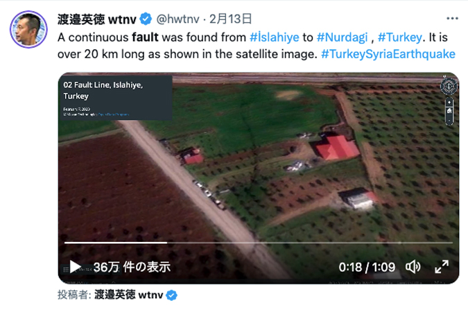
The digital map has also helped locate faults that appeared on the Earth’s surface during the earthquake. Users can find the starting point of the fracture on the satellite image, and the story map is constructed so that the fracture can be traced continuously. By visualizing the data in this way, we can see that a fault runs through a village, that a group of buildings has been destroyed along the fault, and so forth. The map has also helped experts locate new faults.
In addition, I made short videos of the digital map in use and posted them to Twitter. The purpose of this was to make knowledge gained from the map accessible even for those who are unable to access it directly. In this way, I was able to serve as a bridge between the companies that provided the satellite images and the people who were seeking information.
Twenty days after the disaster, MAXAR Technologies’ satellite images were finally available on Google Earth. However, twenty days is a long time for disaster response, and because it requires the installation of a dedicated desktop application, the hurdle for access by the average user is quite high.
This earthquake reminds us that raw satellite image data is only accessible to professionals like research specialists and disaster response organizations, so it can be difficult for members of the general public to handle. The fact that I was able to quickly release digital maps so that anyone could view the damage makes this work significant.
Visualizing a multi-faceted situation
── What were the differences in damage experienced by Türkiye and Syria?
Syrian cities have many low-rise buildings compared to Turkish cities, which makes it difficult to identify damage only by looking at satellite images. To solve this problem, I utilized SAR data, which allows for the detection of changes in the rise and fall of the ground. When objects on the ground are destroyed by an earthquake, the relative height of that area also changes. In other words, by comparing SAR data before and after the earthquake, one can infer that areas in which differences appear, which are shown in red in the embedded video, have been destroyed.
Damage assessment of Azaz, Syria, using SAR (Synthetic Aperture Radar) image differences and satellite images. These are spots where the shape changes before and after the earthquake and where destruction is visible.pic.twitter.com/G2nX4v0KiO#TurkeySyriaEarthquake2023
— 渡邉英徳 wtnv (@hwtnv) February 19, 2023
── What are the important aspects of mapping out disaster information and disaster-stricken areas?
To give an example, a fire that occurred in the Mediterranean port city of İskenderun was covered by media in Japan, but after the fire was extinguished, the event was all but forgotten. However, if you refer to the satellite images map, you can see that actually many high-rise buildings collapsed in the city, highlighting the multi-faceted nature of damage.
One year after the Great East Japan Earthquake, I created the “Great East Japan Earthquake Mass Media Coverage Map (in Japanese)” which shows how mass media reporting after the disaster changed and what areas received little to no coverage. Using this map, we can see that, for example, tsunami damage in Ibaraki Prefecture was hardly reported. I hope to draw on this experience when creating visualizations of damage-stricken areas in places like Syria, which are not easily covered by the media, so that those areas can receive aid.
There is a distance of about 170 km between the Turkish cities of Kahramanmaraş and Antakya, which both received a lot of media coverage. In Japanese terms, this is the same as the distance between Tokyo and Iwaki in Fukushima Prefecture. There are many towns in between those two cities that have suffered devastating damage that has gone unreported in the media. This is precisely the kind of less obvious information on the affected areas that is being sought after.
── What are your plans going forward?
Local volunteers have begun creating and publishing photogrammetric (3D) data, which is important for getting a three-dimensional view of the disaster situation. Using the technology developed for the 3D maps of the war in Ukraine, we are beginning to include this information on the map.
After a disaster, time passes in the blink of an eye. This satellite images map was constructed in real time and has been useful in real time. On the other hand, in order to make use of the information for recovery efforts, it is necessary to archive the disaster situation in a location it can be referred to at any time. When doing so, I feel that we will be able to draw on our knowledge of various mapping and visualizing techniques, such as the digital archives related to the Great East Japan Earthquake that we worked on, and continue medium- to long-term communication with people in the affected areas.
We also need a mechanism for supporting these activities in society as a whole. Therefore, on the 12th anniversary of the Great East Japan Earthquake, I launched the UTokyo Foundation Project “Fund for Digital Archives of War and Disasters.” I intend to utilize this fund for developing and operating digital archives, training the younger generations, and cooperating with disaster-stricken areas.
WATANAVE Hidenori
Professor, Interfaculty Initiative in Information Studies
Graduate of the Department of Architecture in the School of Engineering at the Tokyo University of Science. Ph.D. (Engineering) from the Graduate School of Science and Technology at the University of Tsukuba. Assumed current position in 2018. Creator of “Hiroshima Archive,” “Wasurenai: Shinsai giseisha no kōdō kiroku” (“We Shall Never Forget: Last Moments of Tsunami Disaster Victims”), “Okinawasen dejitaru ākaibu: Ikusa yūkaranu chitēgutu” (“Digital Archive of the Battle of Okinawa: Messages from Wartime”), among others. Author of various works, including Dēta o tsumuide shakai ni tsunagu (“Connecting to Society through Data”) (Kodansha, 2013), and co-author of AI to karākashita shashin de yomigaeru senzen/sensō (“Rebooting Memories of Prewar and War Through Colorized Photographs in Collaboration with AI and Human” (Kobunsha, 2020).
Photo: NAKAJIMA Miyuki
Interview date: February 27, 2023
Interview: Yuki Terada, Hannah Dahlberg-Dodd


