

Investigation
Earthquake, Tsunami: Causes and mechanisms
One of the most important roles of seismologists is to make predictions about and forecast potential earthquakes. Admitting that at least some of the damage of the March disaster may have been avoided had it been performing this role more intently, the seismological community has taken responsibility for its failure and, after much soul-searching, is now taking positive steps to ensure a more proactive approach. On behalf of the Earthquake Research Institute, in the following article I describe what happened on the day of the earthquake and the Institute’s views on what the future holds for the Japanese archipelago.
Satoko Oki
Assistant Professor, Earthquake Research Institute
The earthquake
At 2:46 p.m. on March 11, an earthquake occurred on the plate boundary about 130 km off the coast of the Oshika Peninsula. Two minutes after the initial disturbance, the rupture was propagated over a vast area stretching from offshore Iwate Prefecture to offshore Ibaraki Prefecture. The earthquake hit Sendai 15 seconds after that and Tokyo about a minute later. The Kanto Plain then shook violently for at least two minutes. In central Tokyo, the seismic intensity was a weak 5. This is revealing as, although the magnitude was lower than the inland earthquake that is predicted to hit the Tokyo metropolitan area sometime in the future, the city’s public infrastructure was impacted, exposing vulnerabilities in the system. Below, I outline what happened on the day and why earthquake researchers, including myself, were unable to predict it.
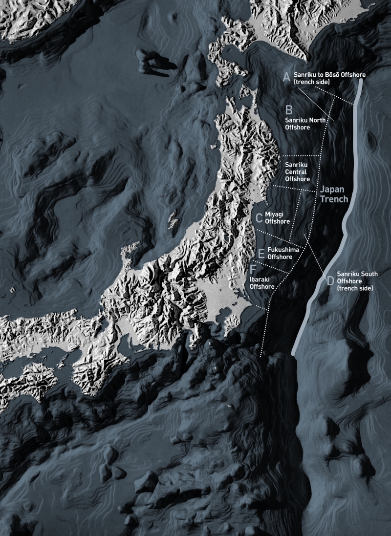
Offshore regions of Japan.
Pre-earthquake assumptions
Since March 11, the word “unforseeable” has been tossed around by both the Meteorological Agency and the government’s Earthquake Research Committee. But this naturally begs the question: what earthquakes are forseeable? After the Kobe earthquake, the Earthquake Research Committee made a commitment to providing the public with more concrete and specific information and decided to publish the results of its evaluations on long-term seismicity. The thinking behind this move went as follows: It is currently almost impossible to predict when an earthquake occurs, but by studying past earthquakes to some extent we can predict the location and intensity of future earthquakes. We have lots of records of undersea earthquakes, which occur at relatively short intervals of several decades to several centuries. From these we can predict the probability that an earthquake will occur within a certain period, together with its intensity and location. The committee has since been announcing the results of its evaluations on long-term seismicity.
Past evaluations by the committee on the long-term seismicity on the Pacific Ocean side of the Tohoku region outlined the probability of earthquakes occurring, together with possible intensity, for seven coastal areas. The largest magnitude predicted was 8.2, and even that was for a scenario in which two linked earthquakes occurred. This evaluation represents the scope of what we are able to “foresee.” The vastness of the source area, extending from the area offshore Iwate Prefecture to that of Ibaraki Prefecture, and the magnitude of 9.0 were indeed outside that scope.
Huge tsunami caused by the earthquake
The source area was much larger than assumed and the shaking of the ground surface and the size of the tsunami also far exceeded expectations. Aerial news footage showed people trying to escape the tsunami approaching from three directions by car only 30 minutes after the earthquake hit. I was stunned to witness these tragic events unfolding, events I had never anticipated. As a result of subsequent surveys, it was revealed that more than half of the victims encountered the tsunami outside the areas marked for flooding on the hazard map. Many more who had taken shelter at evacuation centers were also swept away. If the research community had included such a massive earthquake within the scope of our assumptions, much suffering could have been avoided, which is something we must sincerely acknowledge once again. We were unable to fulfill one of our most important roles as scientists, which is to make forecasts and predictions. It is truly tragic that many people fell victim to the tsunami because they trusted in the data provided by scientists.
| Area | Magnitude | Probability of an earthquake occurring in the next 30 years | Average interval of activity | ||
|---|---|---|---|---|---|
| Offshore area from Sanriku to Boso along the Japan Trench | Tsunami earthquakes | Around Mt 8.2 (Mt: Size of earthquake calculated based on the height of tsunami) |
Around 20% (around 6%)* |
About 133.3 years (530 years)* | |
| Normal-faulting earthquakes | Around 8.2 | 4% to 7% (1% to 2%) |
400 to 750 years (1600 to 3000 years)* | ||
| Northern part of the Sanriku offshore area | Characteristic earthquakes | Around 8.0 | 0.5% - 10% | About 97.0 years | |
| 42.6 years ago | |||||
| Interplate earthquakes other than characteristic earthquakes | 7.1 - 7.6 | Around 90% | About 11.3 years | ||
| Offshore area of Miyagi Prefecture | Around 7.5 | Linked, around 8.0 | 99% | 37.1 years | |
| 32.6 years ago | |||||
| Southern part of the Sanriku offshore area along the Japan Trench | Around 7.7 | 80% - 90% | About 105 years | ||
| 113.4 years ago | |||||
| Offshore area of Fukushima Prefecture | Around 7.4 (sequential occurrence of multiple earthquakes) | About 7.4% or lower | 400 years or more | ||
| Offshore area of Ibaraki Prefecture | 6.7 - 7.2 | About 90% or higher | About 21.2 years | ||
| 2.7 years ago | |||||
| Figure in parentheses: Interval for a specific sea area. Data: Headquarters for Earthquake Research Promotion. Announced before the occurrence of the Tohoku Region Pacific Coast Earthquake. | |||||
Dynamics of the hypocenter
A range of models have been proposed to show which parts of the vast source area were ruptured in what way and to understand how the tsunami was triggered. Tsunami waves tend to increase in height as they approach the coast. In the March earthquake, tsunami waves as high as nearly six meters were observed in offshore areas. As the cause of the phenomenon, the following factors are suggested: fault movements in an area extending over several dozen meters around the Japan Trench, where the Pacific plate subducts beneath Japan; sea bottom movement that caused tsunami waves to become high locally; and large-scale sea bottom slides. For the seismologic community to reach a consensus on the matter, however, we need to conduct more surveys and analyses.
Future of the Japanese archipelago
Since March 11, the seismic status of the eastern part of Japan has changed significantly. In addition to the frequent aftershocks sweeping the Pacific Ocean side of the country from Tohoku to Kanto, induced earthquakes have also hit Nagano, Shizuoka and Fukushima. It is now quite possible for a magnitude 7 earthquake to hit anywhere in the eastern part of Japan, and people need to take safety measures against possible earthquakes both at home and at work.
In our capacity as scientists, we must squarely face up to the disaster that has caused such tremendous damage to society. As a community of researchers who are earnestly investigating the phenomena that were caused by the earthquake, we must attempt to glean as much information as possible to inform future preparations. As members of society, we are steadfastly determined to contribute to building a culture that is highly resistant to disasters and takes steps to minimize the damage of future earthquakes.