


Facing both Captivating Beauty and Menacing Threats
The beauty of Fuji and the many mountains surrounding it vie for the awe of those who visit. Hot springs steam in their foothills and the coastline hints of the country’s rich and varied history. Japan, this bow-shaped archipelago, has been blessed with a beauty that charms both residents and tourists alike, confidently pledging pleasure and relaxation to all.
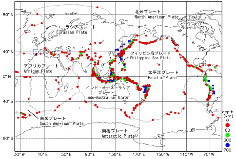 [Figure 1] Distribution of earthquakes recording above magnitude 6
and plate boundaries (from the Cabinet’s 2013 White Paper on
Prevention of Disasters).
Note: 2003-2012
Produced by the Japan Meteorological Agency based on US Geological
Survey data
Deeply intertwined with the country’s appeal is the geo-scientific location of its islands.
Of the 14 or 15 tectonic plates known in the world, four converge on Japan, where over 2000 active faults can be found. According to the 2013 White Paper on Disaster Prevention, issued by the Cabinet, some 20% of earthquakes in the world measuring magnitude 6 or over occur in or around Japan. Further, there are 110 active volcanoes in Japan accounting for about 7% of such volcanoes in the world.
Earthquakes and volcanic activity pose a major threat to residents. In addition, related disasters, such as tsunami, caused by these temblors, can impact a vast area.
In the modern age, one catastrophe can have an impact on environments, economies, industries and societies throughout the world.
For disaster prevention and for reducing the scale of disasters, thorough observation, painstaking data collection and analysis and meticulous research are all vital.
These issues require a global approach that looks at earthquake-prone areas and other locales recording frequent volcanic phenomena like the Pacific region including Japan, the US West Coast, Indonesia, South America and the Mediterranean Coast.
It is also necessary to understand the interior dynamics of the Earth, the very source of the earthquakes and volcanic activity, to explore why they occur.
Japan is the closest place on Earth to finding answers to these issues.
Top-level Observation Technology
The study of earthquakes took shape in Japan as seismology in the late 19th century. The Imperial Earthquake Investigation Committee was founded in the year following the Nobi Earthquake of 1891 (magnitude 8) which, together with the catastrophic Kanto Earthquake (magnitude 7.9) in 1923, led to the establishment, in 1925, of the Earthquake Research Institute at Tokyo Imperial University (now the University of Tokyo), with the new agency effectively taking over responsibilities from the earlier Imperial Earthquake Investigation Committee.
Since then, the Earthquake Research Institute has continued earthquake observations, establishing observation networks and investigating various phenomena associated with earthquakes and volcanic activity. In recent years, by developing the kind of sophisticated industry-leading observation equipment introduced below, the Institute has been able to conduct studies at sites previously considered too challenging.
Through these developments and the tireless efforts led by a team of national universities such as UTokyo, Japan has achieved recognition as an earthquake research authority on par with the United States.
Features of Observation Methods at ERI
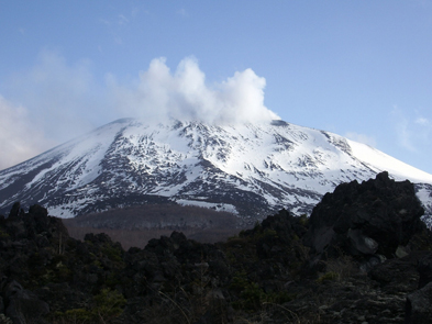 Mt. Asama, site of one of UTokyo's volcanic observatories
The Earthquake Research Institute, the University of Tokyo (ERI) is made up of four divisions responsible for basic research, eight centers geared for specific missions, as well as other supporting offices and sections.
Each center has its own mission-specific observation network.
For example, the Volcano Research Center has volcanic observatories and other facilities on Mt. Asama, Mt. Kirishima, and Izu-Oshima Island. A network has also been established permanently on Mt. Fuji, serving as an important hub for Japan’s volcanic activity observation.
At the time of the 2011 magma eruption of Mt. Shinmoe in the Kirishima mountain range, two observation networks were quickly set up. Together, the broad-band geodetic observation network and acoustic network allowed significant advances in the understanding of magma activity. An unmanned helicopter was used to set up an earthquake GPS observation point near the crater to take a video of the crater surroundings, as well as capture interior details. In addition, an aeromagnetic survey was conducted across the crater area. The breakthrough observation marked a new page in earthquake research.
The Earthquake Prediction Research Center seeks a comprehensive understanding of the mechanism of earthquakes through observing earthquakes and electromagnetics, as well as through geological surveys, with the aim of advancing earthquake prediction. Immediately after the devastating Great East Japan (Tohoku) Earthquake of March 11, 2011, seismometers were installed not only on land but also on sea floors, to start observations of aftershocks. An observation network continues to be maintained in the region for elaborate analyses to bring new knowledge to the field.
For large earthquakes in the world, the Earthquake and Volcano Information Center collects data on geophysical records made available through the observation equipment as well as from past records using historical seismology research techniques. Trigger mechanisms are further examined through coastal topography and a study of tsunami deposits. Over 10 field studies have been conducted to research the tsunami that occurred after the Tohoku Earthquake. The estimated height of the tsunami at 300 locations is being analyzed along with data gauging tsunami waveforms in the open sea in hopes of discovering what triggers giant tsunami.
The observation networks are expanding and so are the actual subjects of study. The Ocean Hemisphere Research Center, as the name implies, conducts research of the “sea hemisphere,” for a deeper appreciation of the activity at the earth’s interior, aiming to get a more systemic recognition of Earth. For six years from 1996, the Center, in cooperation with researchers throughout the country, conducted the “Sea Hemisphere Plan” to expand the world's first comprehensive geophysical observation network to research earthquakes, electromagnetics and geodetics in the western Pacific. Further, the center also developed the world’s most advanced ocean bottom seismic and electromagnetic mobile array equipment to research earthquakes and electromagnetics. Through these major developments, along with analyses of the subduction of the Pacific Ocean plate and stagnation in the transition zone, exciting new facts have been discovered.
![[Figure 2] Observatory Facilities of the Center for Geophysical Observation and Instrumentation](/content/400027041.jpg) [Figure 2] Observatory Facilities of the Center for Geophysical Observation and Instrumentation
[Figure 2] Observatory Facilities of the Center for Geophysical Observation and Instrumentation
Seeing through the Earth’s Interior using Elementary Particles
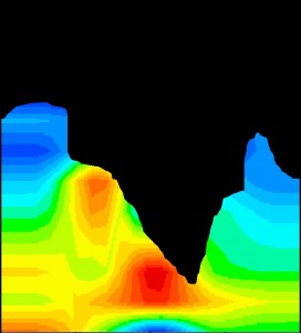 [Figure 3] Muographic image of Mt. Asama
Colors show the mean density of muons.
Red signifies a higher mean density of muons,
with solid red indicating magma that has
cooled after extrusion.
(C) 2014 Hiroyuki Tanaka
What goes on at the Earth’s interior? New muographic imaging using elementary particles enables a new approach to this question that does not rely on conventional methods of indirect observation.
Hiroyuki Tanaka, Professor at the Center for High Energy gEophysics Research (CHEER), developed muongraphy technology for imaging the interior of the Earth from the surface using highly permeable cosmic rays known as muons. In 2007, he announced his “Muographic Images” showing the interior of Mt. Asama. In 2008, the observation system that deployed the technology was able to verify the magma convection hypothesis of Mt. Iwo on Satsuma-Iwo Island. After shooting intermittently through 2013, Tanaka was able to detect vertical activity of magma at Mt. Iwo.
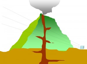 [Figure 4] The principle underlying the visualization
of the volcanic interior.
The direction and number of muons passing horizontally
through the volcano are measured.
(C) 2014 Hiroyuki Tanaka
Studies using neutrinos, which have much higher penetrating power than muons, are also moving forward. Using “IceCube,” the world’s largest neutrino detector, located in the South Pole, an elaborate project is under way to see through the Earth. The Center joins an international research team with members such as the University of Wisconsin in the ongoing research for the imaging of the Earth’s interior.
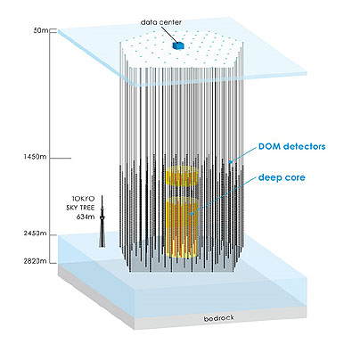 [Figure 5] The IceCube neutrino observatory
(C) 2014 The University of Tokyo.
In cooperation with the UTokyo Department of Physics, the Center has long been attempting to integrate particle physics, a field that has led Japan’s science scene to new heights, into geophysics, in order to explore new areas of science. The Center will continue to join domestic and international research efforts to explore phenomena occurring at the interior of volcanoes and the Earth, introducing new perspectives to earth science.
Japan offers many opportunities for research in seismology and volcanology. As more and more observation data is collected, new observation technologies are developed and an increasing number of domestic and international research teams and other connections are forged, the focus of study also expands beyond the boundaries of research of volcanic activity in one country to a study of the entire planet.
What secrets of the Earth will be uncovered next?


